Lundy, island in the Bristol Channel, England, July 2021
Lundy is an island in the Bristol Channel. Officially it forms part of the district of Torridge in the northern part of the county of Devon, England. It is the largest island in the Bristol Channel at approximately 3 miles (5 kilometres) long and a little over half a mile (or 1 kilometre) wide. Lundy lies 12 miles (19 kilometres) off the north Devon coast, and is reached by the Oldenburg, a passenger boat from Ilfracombe, several days a week between April and October. The island can be reached by helicopter in winter.
Lundy has had a long and turbulent history, frequently changing hands between the British crown and various usurpers. As a steep, rocky island, often shrouded by fog, Lundy has been the scene of many shipwrecks, and the remains of its old lighthouse installations are of both historic and scientific interest. Another attraction is the island’s puffin colony. In 2010, the island became Britain’s first Marine Conservation Zone.
Wednesday, 21st July 2021.
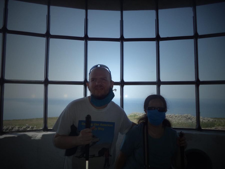
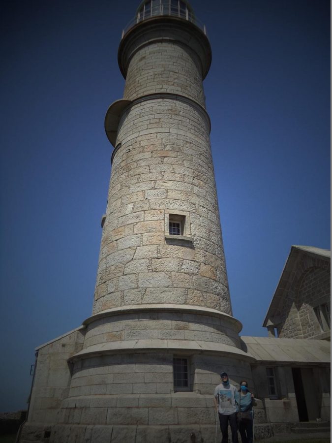
The harbour on Lundy, which is located towards the south-east corner of the island. A substantial concrete jetty extends out into the sea. The harbour is accessed via a gravel track known as the Beach Road.View of the east side of Lundy from the harbour. A rocky shoreline with the cliffs blending into steep grassy slopes above. A few small boats moored in the sea: mostly sailing boats with single masts.A scattered group of buildings in the central southern part of the island, which includes solidly built stone houses, as well as barns and other structures. Most of the island’s inhabited buildings are here along with its pub and church. There is a resident population of around 28.Tony and Tatiana inside St. Helen’s Church with the main altar behind. In view is a stone altar screen with three alabaster panels depicting the Last Supper and beneath a large hand-made crochet tapestry depicting the landscape on Lundy. The tapestry shows the sea, rocks and grass, along with a single tree bent by the wind, all in a stylised design.The chancel of St. Helen’s Church with Tatiana and Tony by the altar at the far end. A stained glass window above the altar and wooden pews along the sides of the chancel. St. Helen’s Church is a Grade II listed Anglican church built in 1896. It was designed by the architect John Norton in a gothic revival style and could hold up to 300 people.Tony and Tatiana outside the main entrance to St. Helen’s Church. They are at the top of steps in front of the porch.Looking up at the tower of St. Helen’s Church. Tony and Tatiana outside the porch at the base. Above is a niche containing a carving of Saint Helen holding a cross and towards the top a clock face. Saint Helen or Elen, after which the church is named, was a late 4th-century founder of churches in Wales. She is traditionally said to have been a daughter of the Romano-British ruler Eudaf Hen (Octavius), and the wife of Macsen Wledig (Magnus Maximus), a 4th-century emperor in Britain, Gaul, and Spain.View from outside St. Helen’s Church showing the rolling grassy landscape with the sea extending to the horizon beyond.Tony and Tatiana inside Lundy Old Light, Lundy’s first lighthouse constructed in 1820. The granite tower is 29 metres (95 feet) in height and it stands on Beacon Hill, which is 143 metres (469 feet) above sea level, making it the highest base for a lighthouse in Britain. The light was often obscured by fog, and to counter this problem, a Fog Signal Battery, equipped with a pair of 18-pound guns, was built about 1861. The lighthouse was deactivated in 1897 when Lundy North Lighthouse was completed. Lundy South Lighthouse was also constructed in 1897.Again Tatiana and Tony inside Lundy Old Light. Part of the circle of windows through which the light shone are behind.An information board inside Lundy Old Light. Some of the text reads: “Built in 1819 at a cost then of £36,000, the light was first used on 21st February 1820. It is 96 feet high with 147 steps, some of them very steep!”View of the exterior of Lundy Old Light with Tony and Tatiana standing at the base.Again Tony and Tatiana at the base of the lighthouse.Tatiana and Tony in front of a blue Lundy Post box in a stone wall. Since 1929 Lundy has issued its own postage stamps due to there being no official Royal Mail post boxes on the island. The stamps, which often depict puffins, can be bought at Lundy Post Office. The stamps pay for transportation to the mainland where Royal Mail stamps are also attached.Entrance to the Marisco Tavern, Lundy’s pub, which is named after one of the most famous and notorious families to own the island. The building was originally the village stores built during the 1860s when the quarrying operation employed around 300 men.A gravel track lined with stone walls close to the Marisco Tavern.Visitors sitting and walking in front of the stone-built Marisco Tavern and other surrounding buildings.View from the harbour jetty showing the deep blue sea and nearby cliffs.Passengers and crew on the jetty waiting for the boat back to the mainland.A narrow rocky channel separating small Rat Island from the rest of Lundy. Rat Island is at Lundy’s south-eastern tip, close to the harbour. It is accessible at low tide.Selfie of Tony with sea and cliffs behind.